


On December 1, the Israel Defense Forces (IDF) released a map of Gaza – divided into 623 numbered blocks – indicating areas the military would imminently strike, and areas to which civilians should flee. It was made accessible online via a QR code printed on leaflets dropped over the strip.
The map, a vestige of the short-lived plan from the 1970s to rebuild Gaza in the early years of Israel’s occupation of the coastal strip, was described by the IDF as “a safe way to preserve your security, your lives, and the lives of your families.”
Residents of Gaza are told to “please pay attention and check this map,” while following “instructions of the IDF through various media outlets.”
The IDF also claimed that they struck the areas identified in this report after “intelligence indication that these places were safehouses for commanders of the Rafah Brigade of the Hamas terror organization.”
“The IDF continues to operate against Hamas infrastructure and terrorists wherever they are located in the Gaza Strip,” the statement continued.
Strikes in areas civilians directed to
On December 2, the IDF’s spokesperson for Arab media, Avichay Adraee posted evacuation orders on social media for citizens in parts of the Gaza Strip, which the IDF had dubbed a “safe zone” in the first month and a half of the war, prior to the truce.
Multiple images of the same location were shared – each with different locations highlighted. On the map, areas to the north and east of the city of Khan Younis are highlighted orange, and arrows instruct residents to evacuate from these areas to Al-Mawasi – a 5.22 square mile coastal strip designated a safe zone by the IDF – or to Rafah, Gaza’s southernmost city.
Aid organizations have raised concerns regarding the Al-Mawasi “humanitarian zone,” with the World Health Organisation’s (WHO) Director-General calling it “a recipe for disaster” due to cramped conditions and lack of infrastructure or services.
Meanwhile, analysis shows, strikes continued to hit Rafah.
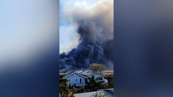
On the afternoon of December 3, a strike took place in Rafah’s El-Geneina neighborhood. Footage, filmed moments after the attack, shows a large smoke plume rising from a location close to Saddam Street in Rafah.
Photographs and videos shared on social media, and geolocated to a position matching the plume, show a large crater and multiple buildings that have been damaged or destroyed.
Local media reported at least 17 people were killed and dozens injured in the attack, which struck the home of the al-Bawab family.
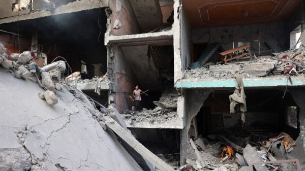
Later that night, another airstrike hit the home of the Al-Jazzar family in the Al-Tanour neighborhood of Rafah. Footage captured in the aftermath of the attack shows individuals desperately searching for survivors in the wreckage. One video shows a man, his legs trapped under rubble, being rescued by Civil Defense teams.
Confusing messaging about safe zones
On December 2, Adraee posted evacuation orders on social media for citizens in the northern Gaza Strip, highlighting a number of blocks to the north of Gaza City, including large parts of Jabalia Refugee Camp. The graphic instructed people in these areas to “evacuate your homes immediately through the Haifa and Khalil al-Wazir axes and go to the known shelter centers and schools in the Al-Daraj and Tuffah neighborhoods and west of Gaza City.”
Adraee attached two inconsistent images to the instructions. Both showed the same area, but the second image had a larger number of blocks deemed unsafe.
This created confusing messaging where certain “blocks” were simultaneously presented as “safe” and “unsafe.” For example, block 720 is not highlighted in the first image, but appears in the orange area in the second image. Block 717, which is partly highlighted in the first image, appears squarely in the orange zone in the second image.
Adraee published updated advice on December 3 in which only the image showing the wider shaded area was included.
On the evening of December 3, a video appeared online which appeared to show a petrol station engulfed in flames. It was released alongside reports that a petrol station in the Al-Tuffah neighborhood of Gaza City had been hit by an Israeli airstrike.
Satellite imagery of the area – provided by Planet Labs on December 4 – reveals destruction and clear signs of fire at the location of the petrol station, located in block 720, an area that was not highlighted in one of the posted maps. The Palestinian Civil Defense later released a statement saying that three members of its civilian team had been killed, and a number of others injured by the bombing.
Planet Labs
On the same day, local reports claimed that the Al-Salam Mosque in the Al-Tuffah neighborhood had been targeted by Israeli strikes.
Satellite imagery of the area does not reveal clear damage to the mosque, but there are signs of bombing in the surrounding area.
Although it has not been possible to confirm the exact date of this attack – which hit block 717 – satellite imagery analysis reveals the strike took place between December 2 and 9, in the days following Adraee’s post correcting initial map.
The IDF says that the maps are reflective of a commitment to ensuring “all possible precautions to avoid causing loss of civilian life or injury, adopting all available means.”
But rights groups and international organizations have cast doubt on those claims. The UN Office for the Coordination of Humanitarian Affairs (OCHA) has raised concerns over the accessibility of the map for residents of Gaza, given power outages and telecommunications cuts.
Data from the global internet monitor, NetBlocks, reveals that at times when the IDF was providing evacuation orders for numbered blocks around Gaza, network connectivity in the Rafah governorate was less than a fifth of peak levels. In the Khan Younis governorate, there were times when connectivity was recorded as zero.
“It is unclear how those residing in Gaza would access the map without electricity and amid recurrent telecommunications cuts,” an OCHA briefing said.